Hein
and Wil de Vries Website: Chegga - Mauritania
Last updated
March 2, 2016
Clicking
on any of these photos will open a new browser window showing a larger image.
At 1,200 feet above
sea level and with its location so deep into the Sahara desert, Chegga sees
the extremes of the deserts' temperature. During winter nights frost covers
the ground, while summer days often pass 50º Celsius. During March and
April, the hot, dry sirocco winds blow through the region.
We have measured in April/May 1973 shadow temperatures (in a land where shadows
are far and few in between!) of 56 degrees Celsius (133 degree Fahrenheit).
During trips away from base camp the only available shadow at midday with
the sun almost perpendicular above oneself is underneath the Landrover.
CHEGGA:
For the most adventurous
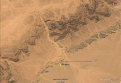
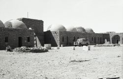
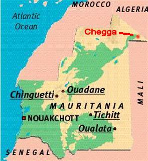
Chegga is situated
in northeastern Mauritania, in a small triangle of land between Algeria and
Mali (bec d'oiseau). (25 degrees 22' 24" N and 5 degrees 47' 13"
W). This remote Sahara site has served as a caravan stop for centuries and
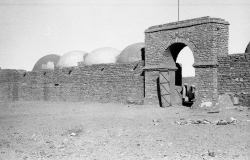
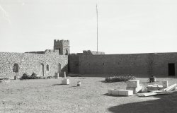
also houses a bordj dating back to the French colonial period (Foreign Legion).
It currently houses the Mauritanian Army.
The main attraction of this locale for the military and other organizations
is the presence of a permanent water source.
Chegga offers little to tourists, and its isolation and the region's instability
make reaching the town perilous.
During the time of our stay
at Chegga we did not meet any of the "Hommes Bleus": the fierce
Regueibat tribe of warriors who are leading a mostly nomadic lifestye in
this vast region. On other occasions and farther West we met and were invited
into their camps and tents. They are a very hospitable people where women
are not veiled and curious young girls often visited our roving camps without
any male "supervision".
The lack of people in the Chegga region testifies to its remoteness and
isolation.
Words
of advice:
Both the British and American governments nowadays strongly advise against
travel to this remote Tiris Zemmour region of northeastern Mauritania, which
includes Chegga.
Bandits and terrorists -- especially those affiliated with Al Qaida in the
Islamic Maghreb --pose a particular threat to Westerners and have killed European
and American visitors. Anyone determined to visit Chegga should exercise extreme
caution: Hire a native guide, form a large caravan, avoid traveling at night
and stop at all government checkpoints.
Searching on Google
for information about CHEGGA I discovered that what is available is probably
provided by persons who never have been there: "small town" ???
Where?? When I was there in 1973 there was no town, no sign whatsoever of
a former town ever have existed in this location.
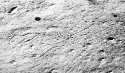
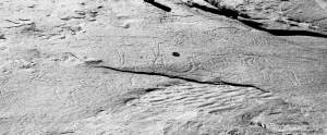
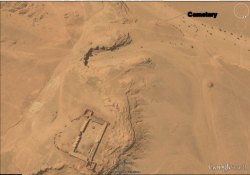
The fort (bordj) the only attraction??? What about the neolithic rock carvings
in the oued above the site?
These Neolothic
engravings are arguably assignable to the First Period (mainly Tazina style).
Many other engravings in the northern region belong to the Tazina style, with
figures incised and distorted, especially in their extremities, which have
a tendency to elongate in an unrealistic way. Also there are incomprehensible
added lines or others which cut indiscriminately through the bodies, making
it very difficult to understand the compositions. The figures are idealized
and have exaggerated anatomical parts, specially the horns. Some figures share
anatomical parts making the compositions still more difficult to read. These
northern engravings are less varied than those attributed to the Tazina style
all over the Sahara, which are dated grosso modo between 4,500 and 2,500 BP
(Muzzolini 1995). However, here there are no horses, carts or clear scenes
of domestication and only one human figure. According to the literature the
themes of this first period or style could evoke the world of the hunter and
is of a much earlier chronology than the proposed by Alfred Muzzolini.
How did I get there?
In 1972-1973 I was the geologist responsible for the exploration and geological
mapping of the sedimentary fringes of the Dorsale Regueibat in the context
of the United Nations Development Program Projet Mau-4.
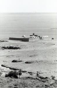
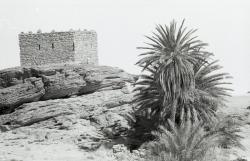
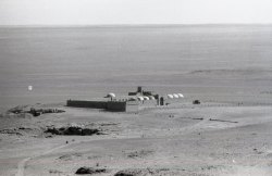
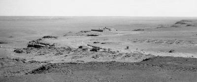
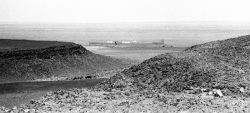
In March 1973 we set up our base camp in this fort: not particular ancient
but dramatic in its setting on the first bluff of the El Hank escarpment rising
out of the sebkha to the North.
This escarpment stretches itself for hundreds of kilometers to the SW and
NE and acts as an excellent "handrail" for navigation purposes (all
this in the era of no GPS and only compass navigation).
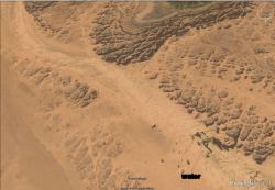
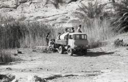
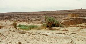
And here the reason
of Chegga's existence: WATER
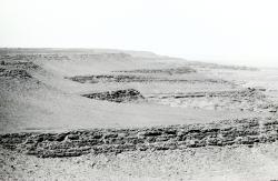
The watersource in Chegga is about 500m. away from the bordj. It
lies in the bed of an ancient oued. Nowadays the water trickles out of the
rocks and is captured in a concrete basin. When we arrived this basin was
filled with reeds and we had to clean a corner in the basin in order to acces
the "eau saumatre": a brackish tasting water high in magnesium content.
For westerners only drinkable when thoroughly cooled.
The reeds and the few palm trees were a very relaxing green environment to
rest in after a day in the relentless sun and heat with only browns and ochres.
Plus the chirping of little birds almost made one feel at home.
However dry and
hot the Chegga region is today, one can find signs of an altogether other
climate almost unimaginable today.
Ostriches, Elephants, Giraffes, wild bovines, used to live in these environs
as the rock engravings testify.
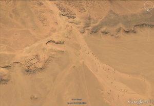
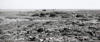
These engravings
are located in the bed of the oued above the Chegga watersource. Most of them
were still very readable in 1973 although the several generations of Legionaires
had done a number on them: 'improved" or otherwise obliterated. Some
have added their own, obviously more modern, engravings.
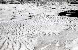
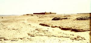
Of course being
a geologist these ripple marks >600 million years old (Precambrian) testify
there is really nothing new under the sun!